
New traffic model calculations indicate that the Eastern Ring Road will divert traffic away from the central parts of Copenhagen while also serving new urban areas in the Eastern Harbour and improve access to the Øresund Link.
The traffic model calculations are part of the environmental impact assessment of the Eastern Ring Road, currently being conducted by Sund & Bælt. These calculations illustrate the impact the Eastern Ring Road will have on traffic compared to a scenario without it. The calculations are based on weekday traffic patterns for the years 2035, 2040, 2050, and 2070.
Over 80,000 Daily Vehicles
The calculations show that by 2050, over 87,000 daily road users will utilize the Eastern Ring Road. This will significantly impact traffic, easing congestion in most of the municipalities of Copenhagen and Frederiksberg, as well as in Gladsaxe, Rødovre, Hvidovre, and Herlev. Central Copenhagen will see a 14% reduction in traffic, while traffic on Knippelsbro will decrease by 25%, and both Langebro and H.C. Andersens Boulevard will experience a 15% reduction.
Reduced Truck Traffic
According to the calculations, truck traffic in Copenhagen will also decrease if the Eastern Ring Road is constructed. By 2050, there will be 18% fewer trucks in central Copenhagen compared to a scenario without Eastern Ringroad. H.C. Andersens Boulevard near Rådhuspladsen will experience a 24% reduction in truck traffic, with other areas like Amager Strandvej seeing a 36% decrease.
Time Savings
The changes in traffic patterns resulting from the Eastern Ring Road will lead to significant time savings for road users in Copenhagen. A rush-hour trip from Tårnby to Gentofte, for example, will be 10 to 20 minutes shorter, while a journey from Lyngby to Amager Strandpark will take 5 to 10 minutes less. The connection will also facilitate commuting between Denmark and Sweden, reducing travel time from the Øresund Link to Nordhavn by 20 to 30 minutes.
Increased Traffic on Some Access Roads
Some roads will experience increased traffic due to higher volumes on access routes to the Eastern Ring Road. This is particularly true for the Helsingør Motorway, Nordhavnsvej, and the Nordhavn Tunnel.
Traffic on the innermost section of the Helsingør Motorway is expected to rise by 28% on an average weekday in 2050, while traffic on Nordhavnsvej is projected to double. Traffic in the Nordhavn Tunnel will quadruple if the Eastern Ring Road is constructed. This may lead to lower speeds and increased travel times on these routes, but overall, the time savings for road users in the capital region are estimated at over 4 million hours annually.
This will also benefit road users on the Motorring 3, the Amager Motorway, and the western section of the Øresund Motorway, which are expected to see traffic reductions of 3%, 6%, and 7%, respectively.
In addition to these effects, the full Eastern Ring Road is expected to strengthen integration within the Øresund Region, as traffic to the Øresund Link is anticipated to increase by 4%.
The environmental impact assessment of the Eastern Ring Road is expected to be completed in 2026, after which political decisions can be made regarding the project.
Assumptions Reviewed
Ahead of the traffic model calculations, Sund & Bælt established a working group comprised of external experts and stakeholders from DTU, CONCITO, the Confederation of Danish Industry, Copenhagen Municipality, By & Havn, Copenhagen Airport, Metroselskabet, Refshaleøens Ejendomsselskab, the Danish Road Directorate, and the Ministry of Transport. This group collaborated with Sund & Bælt to define the assumptions underlying the traffic impact calculations for the Eastern Ring Road.
The traffic model calculations represent a qualified estimate of future traffic patterns based on the assumptions established prior to the analysis. Calculations have been made for the years 2035, 2040, 2050, and 2070. The results illustrate the difference in traffic developments with and without the Eastern Ring Road in these years.
The calculations cover the full Eastern Ring Road, stretching from the Helsingør Motorway and Nordhavn in the north to the Øresund Motorway in the south. Calculations for the first phase of the Eastern Ring Road, from Nordhavn to Lynetteholm, are currently underway and are expected to be published in the second half of 2025.
Selected Effects of the Eastern Ring Road per Weekday in 2050
-
14% fewer vehicle kilometers in central Copenhagen.
-
15% fewer vehicles and 24% fewer trucks on H.C. Andersens Boulevard.
-
31% fewer vehicles and 36% fewer trucks on Amager Strandvej.
-
20% fewer vehicles and 23% fewer trucks on Østerbrogade.
-
355% more vehicles and 193% more trucks in the Nordhavn Tunnel.
-
Some capacity challenges in central Copenhagen, Knippelsbro, and Langebro are reduced or eliminated.
-
The combined time savings for road users in the capital region with the Eastern Ring Road exceed 4 million hours annually.
Read the assumptions report here.
Read the traffic model calculation report for the Eastern Ring Road here.
Read more about the Eastern Ring Road here.
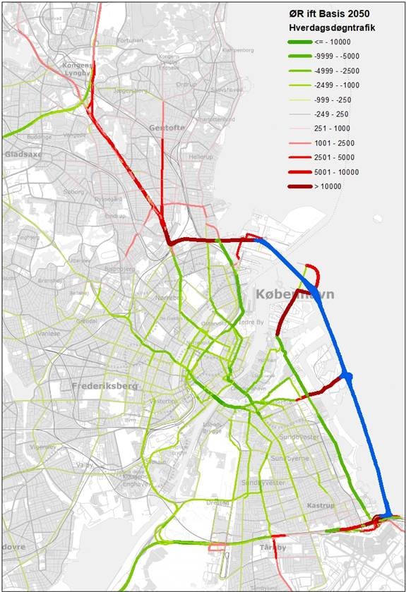
Image caption: The map illustrates how daily traffic patterns will change in 2050 with the construction of the Eastern Ring Road, marked in blue on the map. Green roads will experience reduced traffic, while red roads will see an increase in traffic. The map shows how the Eastern Ring Road will divert traffic away from central Copenhagen in 2050, while access roads like the Helsingør Motorway will face increased traffic.
See map in full size here.
